

Henry Grabar writes, in his most recent Science of Cities column for the online magazine Next Cities (here), that some researchers are trying to reduce a city’s image to data points. Their thinking is to develop a metric that captures a city’s image precisely, so the “brand” can be used to attract various audiences – residents, entrepreneurs, businesses, and tourists. But, is this just an effort to over-simplify the complexity that is part and parcel of a city? At IfYouWereMayor.com we ask whether a city’s true self is completely captured by an image on a postcard, or is there is more to the city than meets the eye?
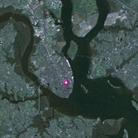
From 30,000 feet, the Charleston region is very much characterized by the water and a healthy dose of green forests and marshlands, especially at its boundaries. Early European settlement on the peninsula was focused in the southeast quadrant – it was high ground and provided for a port protected by the natural configuration of the harbor and barrier islands. This spot also apparently attracted the earlier native people, the Kiawah (Gene Waddell’s Indians of the South Carolina Lowcountry, 1562-1751).
Rather than guiding more recent settlement patterns of the region or signifying the Charleston “brand,” these inherent geographic features have often been paved over, filled in, or otherwise compromised, all too often to facilitate the convenience of large real estate development or the route of a powerline. This is not just a recent phenomenon, but includes the filling of many of the peninsula’s natural tidal creeks and construction of the High Battery. For those with an interest in the particulars, the Preservation Society of Charleston has an incredibly interesting interactive resource on the shaping of the peninsula as it now exists, using the 1948 map by Charlestonian Alfred O. Halsey (here).
The water, marsh, and various types of lowcountry forests, while diminished, are still hallmarks of the region. What shape would the region’s future development take if it were to use these geographic elements as points of departure? Would we reveal some of those in-filled creeks that perfectly align with many of the city’s areas subject to flooding during rain “events” (and even extreme high tides)? Would public access to the waterways more readily allow for kayaks, canoes, small sailboats, or ferries? Would we cultivate our urban and suburban forests to create more shade on our streets and homes? Would some buildings really have to float or stand over areas that allow tidal flow like the buildings in Venice?
Embracing the geographic realities in the future development of the Lowcountry could make the region more resilient in the face of large storms or rising sea levels, and might capture the imagination of the region as a whole. The Coastal Conservation League has posted a Project proposal related to resiliency and climate adaptation here. Make sure you follow the link to the resiliency plan for Brooklyn. The way they plan to reshape the waterfront edges as green park zones to absorb more tidal flow may be a sign of things coastal cities will have to consider.
We may need to adjust our preconceptions, or our “brand,” to embrace all the aspects that make the entire region special, not just the beautiful historic buildings that are an attraction to visitors and newcomers alike. And, we might find that we must capitalize on the longer traditions of the Lowcountry.